Mapping Gray's 'Journal'
Gray's 'Journal': Base Map
/Gray Base Map Power Point 3.gif)
This first base map provides a simple visualisation of Gray's account of his movement through the Lake District landscape over time. But what are the strengths of this map?
This base map allows the user to see where and when Gray travelled through the Lakes in the autumn of 1769: it illustrates the way in which his tour was punctuated by overnight stays in the built environments of Penrith, Keswick, Kendal and Lancaster; and it highlights the linearity of Gray's excursion as he moves into, and back out of, the central Lakes. This map, however, is not without its problems and limitations. This GIS highlights the difficulties associated with the use of a spatially-referenced database: the Digimap Gazetteer. The place names mentioned in Gray's 'Journal' were located on this database and, in almost all cases, the Gazeetter produced the correct geographical co-ordinates (northing and easting). Rivers, though, proved problematic as Digimap produced several pairs of co-ordinates relating to various sites along the length of a particular stretch of water. The weakness of this mapping system is shown, on the base map, with an erroneous reference to a point on the River Eden; a co-ordinate which suggests that, in the early stages of his tour, Gray 'doubled-back' on himself. Although this is a basic mis-mapping of Gray's 'Journal', this errant co-ordinate has been left in place on the map: this anomaly highlights the shortcomings of an automatically-generated spatial database.
A similar problem is created by the use of straight lines to signify the path of movement through the Cumbrian topography. According to this base GIS, Gray's journey from Keswick to Grasmere took him along the western shore of Thirlmere; but his 'Journal' makes it clear that this journey was made on the opposite side of this particular lake. The straight line methodology offers a visualisation of the shortest possible route between two fixed co-ordinates. However, this inflexible way of mapping fails to reflect the non-linear nature of physical movement through space.
Connected with this, this static GIS does not enable the literary cartographer to move beyond the limitations of fixedness associated with the book-based map. One of the core aims of this pilot project is to test whether the use of digital mapping can facilitate further theoretical thinking about the literature of place and space; the work is underpinned by the belief that GIS technology can provide an appropriately flexible, and multi-layered, representational environment. This base GIS serves to map out Gray's historical movement through both space and time; but there is also a need to think about literary cartographies in more imaginative and exploratory ways.
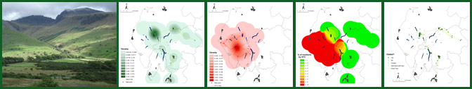
Gray's 'Journal': Smooth Surface Maps
/New Gray - y surface small.GIF)
/New Gray - all surface small.GIF)
These 'smooth surface' maps build on top of the base map; and this second tier of mapping begins to open up some of the spatial/critical possibilities offered by the creation of a literary GIS. The first map illustrates only those places to which Gray refers when he actually positions himself at that location. The second GIS maps out all of Gray's place name references. As a result, the second map identifies what might be described as imaginative spaces: places which Gray names in his text but which he does not claim to have visited.
The two GIS maps use a system of gradation - or, to be more precise, a 'density smoothing technique' - to map out all of the place names to which Gray refers in his 'Journal'. In short, the various shadings relate to the frequency of Gray's naming of specific locations: the darker that an area is shaded, the greater the number of explicit references to sites in that particular vicinity. At this stage of the cartographical process the maps are still produced through the aggregation of quantitative, rather than qualitative, data; that is to say, they cannot represent Gray's subjective, emotional textual response to the Lake District landscape.
The creation of these 'smooth surface' maps points the way towards further cartographical practices and spatial thinking. The area in which Gray's place naming is most intense is the landscape in and around the town of Keswick. This proliferation of place names is reflective of the fact that Gray spent a total of six nights in this particular part of the Lake District; and, by extension, a significant amount of his 'Journal' is dedicated to reflections of geo-specific experiences in this area. Yet, as well as mapping out the density of Gray's place naming, the density smoothing technique may also produce a visual guide to the imaginative centre of Gray's spatial experiences in the Lakes. These 'smooth surface' GIS maps suggest that the area immediately around Keswick provided Gray with his most heightened geographical experiences during his excursion.
As a result, these literary GIS maps do not offer a dramatic reconfiguration of our understanding of the representations of space in Gray's 'Journal'. Instead, they offer an attractive and useful visualisation of the sense of place which is articulated in Gray's text; the map reinforces the notion that the area around Keswick provided Gray with his spatial and imaginative 'hot-spot'.
By extension, these smooth surface maps also serve to highlight the hierarchisation of place which is embedded in Gray's 'Journal'. The use of the density smoothing technique illustrates the way in which Gray appears to privilege certain experiences of landscape over others in his textual account of the Lakes. As mentioned earlier, the darker shadings on the map highlight an abundance of place name references and spatial descriptions; in contrast, the lighter shadings illustrate those spaces through which Gray passes with minimal description or attention to detail.
Ultimately, GIS might also be able to map anomalous representations of space: textual 'data' which might throw up surprisingly irregular spatial patterns. Perhaps the greatest possibilities presented by this kind of digital mapping may lie in the aggregation, geo-referencing and cartographical representation of a more substantial corpus of texts by a range of authors..